
Mapa topográfico Homer
Mapa interactivo
Haga clic en el mapa para ver la altitud.
Acerca de este mapa
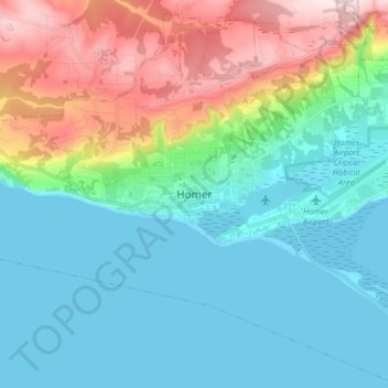
Nombre: Mapa topográfico Homer, altitud, relieve.
Lugar: Homer, Kenai Peninsula, Alaska, United States (59.60409 -151.58015 59.68409 -151.50015)
Altitud media: 106 m
Altitud mínima: 0 m
Altitud máxima: 395 m
Some birds seen during the spring migration and the festival include horned puffins, sandhill cranes, and arctic terns. Arctic Terns are famous for flying the longest distance of any migrating bird. Many of the birds seen during the festival can be identified with the help of published guides that categorize distinguishable features such as, topography, silhouette, size, and color. The festival also includes the Shorebirds Sing: Bird Call Contest, where contestants compete to mimic the calls of various bird species.