
Haz una donación
Mapa topográfico Lake Monroe
Haga clic en el mapa para ver la altitud.
Haz una donación
Lake Monroe
Monroe Lake is a reservoir located about 10 miles (16 km) southeast of Bloomington, Indiana, United States. The lake is the largest entirely situated in Indiana with 10,750 acres (43.5 km2) of water surface area spread over the counties of Monroe and Brown. Capacity varies from 292 gigalitres (237,000 acre⋅ft) to 428 gigalitres (347,000 acre⋅ft) depending on water level. It is also home to 13,202 acres (53.43 km2) of protected forest and three recreational areas (Fairfax, Hardin Ridge, and Paynetown). Indiana's only federally protected U.S. Wilderness Area, the 13,000-acre (53 km2) Charles C. Deam Wilderness Area, is located on the south shore. The lake's watershed is 441 square miles, 82% of which is forested or farmland. The pool elevation (above sea level) is about 538 feet (164 m) year-round. During colder winters, limited ice fishing is available on protected backwater portions of the reservoir.
Haz una donación
Acerca de este mapa
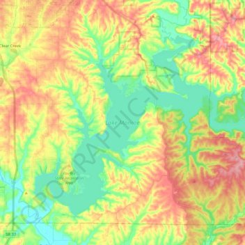
Nombre: Mapa topográfico Lake Monroe, altitud, relieve.
Lugar: Lake Monroe, Monroe County, Indiana, United States (38.99462 -86.52090 39.12199 -86.31232)
Altitud media: 205 m
Altitud mínima: 150 m
Altitud máxima: 272 m
Haz una donación
Otros mapas topográficos
Haga clic en un mapa para ver su topografía, su altitud y su relieve.