
Haz una donación
Mapa topográfico Velbert
Haga clic en el mapa para ver la altitud.
Haz una donación
Velbert
Velbert stands on the highest part of the Niederberg region and also in its centre. Its average elevation is around 230 metres above sea level; its highest point, at 303 metres, is the Hordt-Berg, and its lowest, at around 70.6 metres, is in Nierenhof am Deilbach. The highest point in Velbert itself is 263 metres above sea level, at the corner of Friedrichstraße and Langenberger Straße.
Haz una donación
Acerca de este mapa
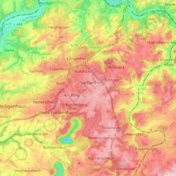
Nombre: Mapa topográfico Velbert, altitud, relieve.
Lugar: Velbert, Kreis Mettmann, North Rhine-Westphalia, Germany (51.29318 7.00124 51.38152 7.16976)
Altitud media: 172 m
Altitud mínima: 19 m
Altitud máxima: 292 m
Haz una donación
Otros mapas topográficos
Haga clic en un mapa para ver su topografía, su altitud y su relieve.
Abtsküche / Haus Hetterscheidt
Germany > North Rhine-Westphalia > Kreis Mettmann > Heiligenhaus > Tüschen
Altitud media: 168 m