
Mapa topográfico Rangeworthy
Mapa interactivo
Haga clic en el mapa para ver la altitud.
Acerca de este mapa
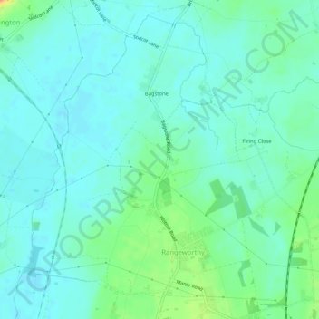
Nombre: Mapa topográfico Rangeworthy, altitud, relieve.
Altitud media: 59 m
Altitud mínima: 48 m
Altitud máxima: 93 m
Otros mapas topográficos
Haga clic en un mapa para ver su topografía, su altitud y su relieve.
Warmley
United Kingdom > England > South Gloucestershire
Warmley, Siston, South Gloucestershire, West of England, England, BS15 4PP, United Kingdom
Altitud media: 69 m
Marsh Common
United Kingdom > England > South Gloucestershire > Easter Compton
Marsh Common, Pilning and Severn Beach, Easter Compton, South Gloucestershire, West of England, England, BS35 4JU, United Kingdom
Altitud media: 10 m
Yate
United Kingdom > England > South Gloucestershire
Yate, South Gloucestershire, West of England, England, United Kingdom
Altitud media: 83 m
Siston
United Kingdom > England > South Gloucestershire
Siston, South Gloucestershire, West of England, England, United Kingdom
Altitud media: 80 m
Alveston
United Kingdom > England > South Gloucestershire
Alveston, South Gloucestershire, West of England, England, United Kingdom
Altitud media: 75 m
Kingswood
United Kingdom > England > South Gloucestershire
Kingswood, South Gloucestershire, West of England, England, BS15 8LQ, United Kingdom
Altitud media: 57 m