
Mapa topográfico Denbigh
Mapa interactivo
Haga clic en el mapa para ver la altitud.
Acerca de este mapa
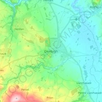
Nombre: Mapa topográfico Denbigh, altitud, relieve.
Lugar: Denbigh, Denbighshire, Wales, LL16 3UN, United Kingdom (53.14538 -3.45783 53.22538 -3.37783)
Altitud media: 102 m
Altitud mínima: 21 m
Altitud máxima: 374 m
Otros mapas topográficos
Haga clic en un mapa para ver su topografía, su altitud y su relieve.
Rhyl
United Kingdom > Wales > Denbighshire
Rhyl, Denbighshire, Wales, LL18 1RG, United Kingdom
Altitud media: 5 m
Y Berwyn National Nature Reserve
United Kingdom > Wales > Denbighshire
Y Berwyn National Nature Reserve, Llandrillo, Denbighshire, Wales, LL21 0TE, United Kingdom
Altitud media: 455 m
Prestatyn
United Kingdom > Wales > Denbighshire
Prestatyn, Denbighshire, Wales, LL19 9LG, United Kingdom
Altitud media: 48 m
Aberwheeler
United Kingdom > Wales > Denbighshire > Bodfari
Aberwheeler, Bodfari, Denbighshire, Wales, LL16 4BT, United Kingdom
Altitud media: 97 m
Corwen
United Kingdom > Wales > Denbighshire
Corwen, Denbighshire, Wales, LL21 0DL, United Kingdom
Altitud media: 274 m
Ruthin
United Kingdom > Wales > Denbighshire > Ruthin
Ruthin, Denbighshire, Wales, LL15 1BU, United Kingdom
Altitud media: 162 m