
Mapa topográfico Benito Juárez
Mapa interactivo
Haga clic en el mapa para ver la altitud.
Acerca de este mapa
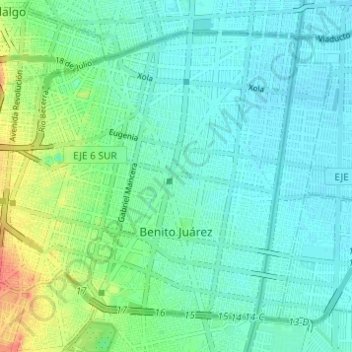
Nombre: Mapa topográfico Benito Juárez, altitud, relieve.
Lugar: Benito Juárez, Mexico City, Mexico (19.35689 -99.19214 19.40406 -99.13094)
Altitud media: 2,244 m
Altitud mínima: 2,231 m
Altitud máxima: 2,282 m
It has a territory of 26.63 km2 (2,661.5 hectares), which is 1.8% of Mexico City, with an average altitude of 2,242 metres. It consists of 56 neighborhoods called "colonias" and three major apartment complexes (unidades habitacionales) which cover 2,210 city blocks and through which some of the most important city thoroughfares pass. The borough is nearly entirely residential with a socioeconomic level of middle class to upper middle class.
Otros mapas topográficos
Haga clic en un mapa para ver su topografía, su altitud y su relieve.
Parque España
Parque España, Condesa, Cuauhtémoc, Mexico City, 06140, Mexico
Altitud media: 2,242 m
Island of the Dead Dolls
Island of the Dead Dolls, Xochimilco, Mexico City, 16043, Mexico
Altitud media: 2,235 m
Bosque de Chapultepec
Bosque de Chapultepec, Mexico City, 11590, Mexico
Altitud media: 2,296 m