
Mapa topográfico High Point
Mapa interactivo
Haga clic en el mapa para ver la altitud.
Acerca de este mapa
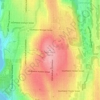
Nombre: Mapa topográfico High Point, altitud, relieve.
Altitud media: 88 m
Altitud mínima: 0 m
Altitud máxima: 160 m
Otros mapas topográficos
Haga clic en un mapa para ver su topografía, su altitud y su relieve.
Queen Anne Hill
United States > Washington > King County > Seattle
Queen Anne Hill, Seattle, King County, Washington, 98109, United States
Altitud media: 55 m
Nantes Park
United States > Washington > King County > Seattle
Nantes Park, West Seattle, Seattle, King County, Washington, United States
Altitud media: 53 m
Licton Springs
United States > Washington > King County > Seattle
Licton Springs, Ashworth Avenue North, Licton Springs, Greenwood, Seattle, King County, Washington, 98113, United States
Altitud media: 96 m
Lemur
United States > Washington > King County > Seattle
Lemur, Phinney Ridge, Seattle, King County, Washington, United States
Altitud media: 59 m
Arbor Heights
United States > Washington > King County > Seattle > Arbor Heights
Arbor Heights, Seattle, King County, Washington, 98146, United States
Altitud media: 60 m
Bitter Lake
United States > Washington > King County > Seattle > Bitter Lake
Bitter Lake, Seattle, King County, Washington, 98133, United States
Altitud media: 112 m