
Gracias por apoyar a este sitio ❤️
Haz una donación
Haz una donación
Mapa topográfico Angamoozhy
Haga clic en el mapa para ver la altitud.
Gracias por apoyar a este sitio ❤️
Haz una donación
Haz una donación
Angamoozhy
Angamoozhy is geographically a high-range area (Malanadu) situated in the south eastern part of Kerala and very close to the Western ghats mountain ranges. It has an average elevation of 18 m (59 ft) above sea level.
Gracias por apoyar a este sitio ❤️
Haz una donación
Haz una donación
Acerca de este mapa
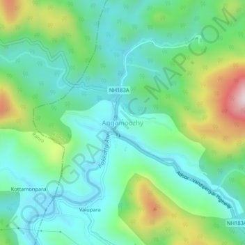
Nombre: Mapa topográfico Angamoozhy, altitud, relieve.
Lugar: Angamoozhy, Konni, Pathanamthitta, Kerala, India (9.34078 76.96881 9.38078 77.00881)
Altitud media: 233 m
Altitud mínima: 76 m
Altitud máxima: 646 m
Gracias por apoyar a este sitio ❤️
Haz una donación
Haz una donación
Otros mapas topográficos
Haga clic en un mapa para ver su topografía, su altitud y su relieve.