
Gracias por apoyar a este sitio ❤️
Haz una donación
Haz una donación
Mapa topográfico Tonna
Haga clic en el mapa para ver la altitud.
Gracias por apoyar a este sitio ❤️
Haz una donación
Haz una donación
Acerca de este mapa
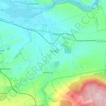
Nombre: Mapa topográfico Tonna, altitud, relieve.
Lugar: Tonna, Fahner Höhe, Landkreis Gotha, Thuringia, 99958, Germany (51.04772 10.69488 51.11184 10.78391)
Altitud media: 228 m
Altitud mínima: 166 m
Altitud máxima: 419 m
Gracias por apoyar a este sitio ❤️
Haz una donación
Haz una donación
Otros mapas topográficos
Haga clic en un mapa para ver su topografía, su altitud y su relieve.