
Haz una donación
Mapa topográfico Kuala Terengganu
Haga clic en el mapa para ver la altitud.
Haz una donación
Kuala Terengganu
As a part of Terengganu, Kuala Terengganu has a tropical rainforest climate under the Köppen climate classification (Af) with constant temperature and high humidity. The amount of rainfall varies according to the monsoon season. It is generally fairly hot and humid all year round, averaging from 28 °C to 30 °C in daytime and slightly cooler after dusk. Nevertheless, the sea breeze from South China Sea hsomehow moderates the humidity in offshore areas while the altitude and lush forest trees and plant has cooled the mountain and rural areas.
Haz una donación
Acerca de este mapa
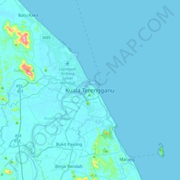
Nombre: Mapa topográfico Kuala Terengganu, altitud, relieve.
Lugar: Kuala Terengganu, Terengganu, 20300, Malaysia (5.16965 102.97833 5.48965 103.29833)
Altitud media: 9 m
Altitud mínima: -1 m
Altitud máxima: 320 m
Haz una donación
Otros mapas topográficos
Haga clic en un mapa para ver su topografía, su altitud y su relieve.
Haz una donación
Haz una donación
Taman Tamadun Islam (Mini Islam)
Malaysia > Terengganu > Kuala Terengganu > Kuala Terengganu
Altitud media: 5 m