
Haz una donación
Mapa topográfico West Point
Haga clic en el mapa para ver la altitud.
Haz una donación
Acerca de este mapa
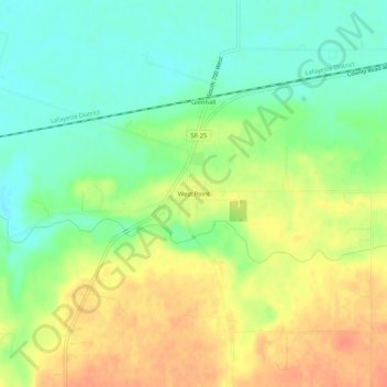
Nombre: Mapa topográfico West Point, altitud, relieve.
Lugar: West Point, Tippecanoe County, Indiana, 47992, United States (40.32468 -87.06218 40.36468 -87.02218)
Altitud media: 198 m
Altitud mínima: 176 m
Altitud máxima: 222 m
Haz una donación
Otros mapas topográficos
Haga clic en un mapa para ver su topografía, su altitud y su relieve.
Dayton
United States > Indiana > Tippecanoe County
Dayton is located in northwest Sheffield Township, at an elevation of 676 feet (206 m).
Altitud media: 203 m
Haz una donación
Battle Ground
United States > Indiana > Tippecanoe County
Battle Ground is located at 40°30′36″N 86°50′18″W / 40.51000°N 86.83833°W / 40.51000; -86.83833 (40.510110, −86.838220) in Tippecanoe Township, one and a quarter miles northwest of the Wabash River. Its elevation is approximately 585 feet. The small Harrison Creek begins near Battle…
Altitud media: 180 m