
Mapa topográfico Slaithwaite
Haga clic en el mapa para ver la altitud.
Slaithwaite
In the 1848 edition of 'A Topographical Dictionary of England', Samuel Lewis (the editor) wrote:- "the lands are in meadow and pasture, with a small portion of arable; the scenery is bold and romantic. In the quarries of the district are found vegetable fossils, especially firs and other mountain trees. The village is beautifully seated in the valley of the river Colne; the inhabitants are chiefly employed in the woollen manufacture, in the spinning of cotton and silk, and in silk-weaving"
Acerca de este mapa
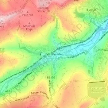
Nombre: Mapa topográfico Slaithwaite, altitud, relieve.
Altitud media: 241 m
Altitud mínima: 107 m
Altitud máxima: 391 m
Otros mapas topográficos
Haga clic en un mapa para ver su topografía, su altitud y su relieve.