
Mapa topográfico Mill River Park
Mapa interactivo
Haga clic en el mapa para ver la altitud.
Acerca de este mapa
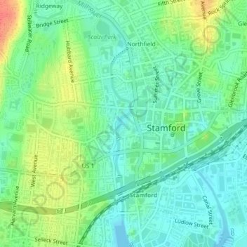
Nombre: Mapa topográfico Mill River Park, altitud, relieve.
Altitud media: 18 m
Altitud mínima: 0 m
Altitud máxima: 53 m
Otros mapas topográficos
Haga clic en un mapa para ver su topografía, su altitud y su relieve.
North Stamford
United States > Connecticut > Western Connecticut Planning Region > Stamford
North Stamford, Stamford, Western Connecticut Planning Region, Connecticut, 06903, United States
Altitud media: 89 m
Shippan Point
United States > Connecticut > Western Connecticut Planning Region > Stamford
Shippan Point, Stamford, Western Connecticut Planning Region, Connecticut, 06926, United States
Altitud media: 3 m