
Mapa topográfico Oakdale
Mapa interactivo
Haga clic en el mapa para ver la altitud.
Oakdale
Historically the area has been used for orchards and other agricultural uses. Some of the common soil types found in Oakdale are Delhi sand, Oakdale sandy loam, Hanford sandy loam, and Tujunga loamy sand. Oakdale is generally on level ground at an elevation of approximately 190 feet (58 m) above mean sea level. Drainage is generally to the northwest towards the Stanislaus River.
Acerca de este mapa
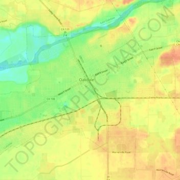
Nombre: Mapa topográfico Oakdale, altitud, relieve.
Altitud media: 52 m
Altitud mínima: 26 m
Altitud máxima: 69 m
Otros mapas topográficos
Haga clic en un mapa para ver su topografía, su altitud y su relieve.
San Joaquin River National Wildlife Refuge
United States > California > Stanislaus County
Altitud media: 14 m