
Gracias por apoyar a este sitio ❤️
Haz una donación
Haz una donación
Mapa topográfico Iguig
Haga clic en el mapa para ver la altitud.
Gracias por apoyar a este sitio ❤️
Haz una donación
Haz una donación
Acerca de este mapa
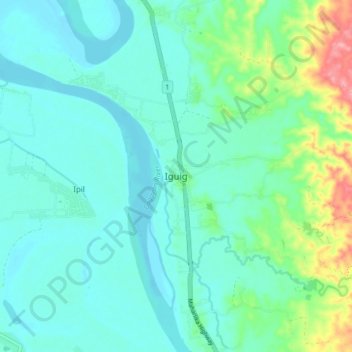
Nombre: Mapa topográfico Iguig, altitud, relieve.
Lugar: Iguig, Cagayan, Cagayan Valley, 3504, Philippines (17.71017 121.69538 17.79017 121.77538)
Altitud media: 30 m
Altitud mínima: 7 m
Altitud máxima: 118 m
Gracias por apoyar a este sitio ❤️
Haz una donación
Haz una donación
Otros mapas topográficos
Haga clic en un mapa para ver su topografía, su altitud y su relieve.
Fuga Island
Fuga has an area of 70 square kilometres (27 sq mi) and a population of 2,015 people. The principal settlement is Naguilian (Musa) village on the southern coast. The highest peak is Mount Nanguringan in the northeast, with an elevation of 191 metres (627 ft).
Altitud media: 9 m
Gracias por apoyar a este sitio ❤️
Haz una donación
Haz una donación