
Mapa topográfico Clinton
Mapa interactivo
Haga clic en el mapa para ver la altitud.
Acerca de este mapa
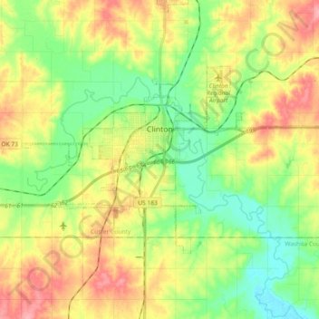
Nombre: Mapa topográfico Clinton, altitud, relieve.
Lugar: Clinton, Custer County, Oklahoma, 73601, United States (35.45769 -99.04621 35.54482 -98.86404)
Altitud media: 481 m
Altitud mínima: 439 m
Altitud máxima: 537 m
Otros mapas topográficos
Haga clic en un mapa para ver su topografía, su altitud y su relieve.
Moorewood
United States > Oklahoma > Custer County
Moorewood, Custer County, Oklahoma, United States
Altitud media: 557 m
Thomas
United States > Oklahoma > Custer County
Thomas, Custer County, Oklahoma, 73669, United States
Altitud media: 535 m
Arapaho
United States > Oklahoma > Custer County
Arapaho, Custer County, Oklahoma, 73620, United States
Altitud media: 494 m
Weatherford
United States > Oklahoma > Custer County > Weatherford > Weatherford
Weatherford, Custer County, Oklahoma, 73096, United States
Altitud media: 517 m
Weatherford
United States > Oklahoma > Custer County
Weatherford, Custer County, Oklahoma, 73096, United States
Altitud media: 514 m