
Mapa topográfico Marktoberdorf
Mapa interactivo
Haga clic en el mapa para ver la altitud.
Acerca de este mapa
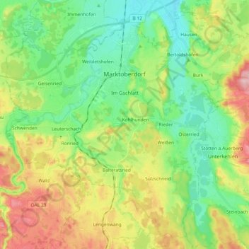
Nombre: Mapa topográfico Marktoberdorf, altitud, relieve.
Lugar: Marktoberdorf, Landkreis Ostallgäu, Bayern, 87616, Deutschland (47.69431 10.52981 47.80565 10.71268)
Altitud media: 770 m
Altitud mínima: 704 m
Altitud máxima: 888 m
Otros mapas topográficos
Haga clic en un mapa para ver su topografía, su altitud y su relieve.
Pfronten
Deutschland > Bayern > Landkreis Ostallgäu
Pfronten, Landkreis Ostallgäu, Bayern, 87459, Deutschland
Altitud media: 1,085 m
Füssen
Deutschland > Bayern > Landkreis Ostallgäu
Füssen, Landkreis Ostallgäu, Bayern, 87629, Deutschland
Altitud media: 852 m