
Mapa topográfico Gangotri National Park
Mapa interactivo
Haga clic en el mapa para ver la altitud.
Acerca de este mapa
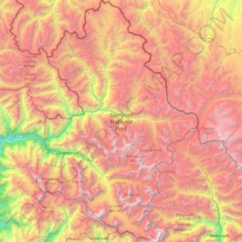
Nombre: Mapa topográfico Gangotri National Park, altitud, relieve.
Altitud media: 5,008 m
Altitud mínima: 2,497 m
Altitud máxima: 7,135 m
The park harbors Western Himalayan subalpine conifer forests at lower elevations and Western Himalayan alpine shrub and meadows at higher elevations. Vegetation consist of chirpine deodar, fir, spruce, oak and rhododendrons.
Otros mapas topográficos
Haga clic en un mapa para ver su topografía, su altitud y su relieve.
Didsari
India > Uttarakhand > Bhatwari
Didsari, Bhatwari, Uttarkashi district, Uttarakhand, India
Altitud media: 1,801 m
Dayara
India > Uttarakhand > Bhatwari
Dayara, Bhatwari, Uttarkashi district, Uttarakhand, India
Altitud media: 3,409 m
Uttarkashi
India > Uttarakhand > Bhatwari
Uttarkashi, Bhatwari, Uttarkashi district, Uttarakhand, 249193, India
Altitud media: 1,619 m
Gangotri
India > Uttarakhand > Bhatwari
Gangotri, Bhatwari, Uttarkashi District, Uttarakhand, India
Altitud media: 4,139 m
Shivling
India > Uttarakhand > Bhatwari
Shivling, Bhatwari, Uttarkashi district, Uttarakhand, India
Altitud media: 5,440 m
Barsu
India > Uttarakhand > Bhatwari > Barsu
Barsu, Bhatwari, Uttarkashi, Uttarakhand, India
Altitud media: 2,322 m
Raithal
India > Uttarakhand > Bhatwari > Raithal
Raithal, Bhatwari, Uttarkashi, Uttarakhand, India
Altitud media: 2,122 m
Bhaironghati
India > Uttarakhand > Bhatwari > Lanka > Bhaironghati
Bhaironghati, Lanka, Bhatwari, Uttarkashi, Uttarakhand, India
Altitud media: 3,227 m
Bhatwari
India > Uttarakhand > Bhatwari
Bhatwari, Uttarkashi district, Uttarakhand, India
Altitud media: 4,572 m
Gangotri Glacier
India > Uttarakhand > Bhatwari
Gangotri Glacier, Bhatwari, Uttarkashi, Uttarakhand, India
Altitud media: 5,259 m