
Mapa topográfico Saintes
Mapa interactivo
Haga clic en el mapa para ver la altitud.
Acerca de este mapa
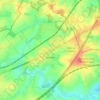
Nombre: Mapa topográfico Saintes, altitud, relieve.
Lugar: Saintes, Tubize, Nivelles, Brabant wallon, Wallonie, Belgique (50.68668 4.13096 50.72908 4.18228)
Altitud media: 62 m
Altitud mínima: 35 m
Altitud máxima: 98 m
Otros mapas topográficos
Haga clic en un mapa para ver su topografía, su altitud y su relieve.
Clabecq
Belgique > Brabant wallon > Nivelles > Tubize
Clabecq, Tubize, Nivelles, Brabant wallon, Wallonie, Belgique
Altitud media: 58 m
La Bruyère
Belgique > Brabant wallon > Nivelles > Tubize
La Bruyère, Tubize, Nivelles, Brabant wallon, Wallonie, 1480, Belgique
Altitud media: 62 m
Egypte
Belgique > Brabant wallon > Nivelles > Tubize
Egypte, Tubize, Nivelles, Brabant wallon, Wallonie, 1480, Belgique
Altitud media: 66 m
Ophain
Belgique > Brabant wallon > Nivelles > Tubize
Ophain, Tubize, Nivelles, Brabant wallon, Wallonie, 1480, Belgique
Altitud media: 57 m
Le Stierbecq
Belgique > Brabant wallon > Nivelles > Tubize > Le Stierbecq
Le Stierbecq, Tubize, Nivelles, Brabant wallon, Wallonie, Belgique
Altitud media: 55 m