
Mapa topográfico Horseshoe Bend
Mapa interactivo
Haga clic en el mapa para ver la altitud.
Acerca de este mapa
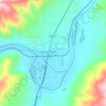
Nombre: Mapa topográfico Horseshoe Bend, altitud, relieve.
Lugar: Horseshoe Bend, Boise County, Idaho, United States (43.89845 -116.21011 43.92994 -116.18873)
Altitud media: 867 m
Altitud mínima: 784 m
Altitud máxima: 1,125 m
The area was originally settled as a gold miners' staging area, as prospectors waited along the river for snows to thaw at the higher elevations. Gold had been discovered in 1862 in the Boise Basin mountains to the east, near Idaho City.
Otros mapas topográficos
Haga clic en un mapa para ver su topografía, su altitud y su relieve.
Placerville
United States > Idaho > Boise County
Placerville, Boise County, Idaho, 83666, United States
Altitud media: 1,343 m
Hawley Mountain
United States > Idaho > Boise County
Hawley Mountain, Boise County, Idaho, United States
Altitud media: 2,023 m
Idaho City
United States > Idaho > Boise County
Idaho City, Boise County, Idaho, 83631, United States
Altitud media: 1,236 m
North Raker
United States > Idaho > Boise County
North Raker, Boise County, Idaho, United States
Altitud media: 2,651 m
Garden Valley
United States > Idaho > Boise County
Garden Valley, Boise County, Idaho, 83622, United States
Altitud media: 1,004 m