
Mapa topográfico Durango
Mapa interactivo
Haga clic en el mapa para ver la altitud.
Acerca de este mapa
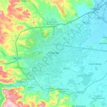
Nombre: Mapa topográfico Durango, altitud, relieve.
Lugar: Durango, Municipio de Durango, Durango, Mexico (23.94563 -104.73078 24.09514 -104.51793)
Altitud media: 1,936 m
Altitud mínima: 1,860 m
Altitud máxima: 2,225 m
Durango (Spanish pronunciation: [duˈɾaŋɡo], Southeastern Tepehuan: Korian) is the capital and largest city of the northern Mexican state of Durango and the seat of the Durango municipality. It has a population of 654,876 as of the 2015 census. The city's official name is Victoria de Durango, Victoria having been added in honor of the first president of Mexico, Guadalupe Victoria, who hailed from the state of Durango. The city is located in the Valley of Guadiana and sits at an altitude of 1,890 m (6,201 ft).