
Gracias por apoyar a este sitio ❤️
Haz una donación
Haz una donación
Mapa topográfico Duncanville
Haga clic en el mapa para ver la altitud.
Gracias por apoyar a este sitio ❤️
Haz una donación
Haz una donación
Acerca de este mapa
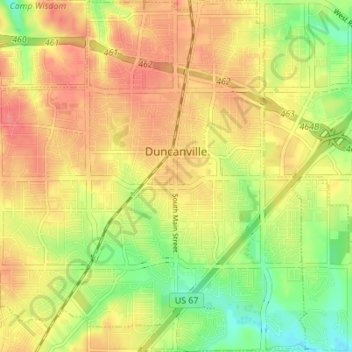
Nombre: Mapa topográfico Duncanville, altitud, relieve.
Lugar: Duncanville, Dallas County, Texas, United States (32.61871 -96.94331 32.67671 -96.88265)
Altitud media: 213 m
Altitud mínima: 178 m
Altitud máxima: 239 m
Gracias por apoyar a este sitio ❤️
Haz una donación
Haz una donación
Otros mapas topográficos
Haga clic en un mapa para ver su topografía, su altitud y su relieve.
Dallas
United States > Texas > Dallas County > Dallas
Dallas and its surrounding area are mostly flat. The city lies at elevations ranging from 450 to 550 feet (137 to 168 m) above sea level. The western edge of the Austin Chalk Formation, a limestone escarpment (also known as the "White Rock Escarpment"), rises 230 feet (70 m) and runs roughly north–south…
Altitud media: 158 m
Gracias por apoyar a este sitio ❤️
Haz una donación
Haz una donación