
Mapa topográfico Potsdam
Mapa interactivo
Haga clic en el mapa para ver la altitud.
Acerca de este mapa
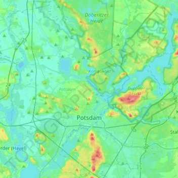
Nombre: Mapa topográfico Potsdam, altitud, relieve.
Lugar: Potsdam, Brandenburg, Germany (52.34204 12.88678 52.51469 13.16820)
Altitud media: 40 m
Altitud mínima: 25 m
Altitud máxima: 103 m
The traditional towns in the governorate were small, however, in the course of the industrial labour migration some reached the rank of urban districts. The principal towns were Brandenburg upon Havel, Köpenick, Potsdam, Prenzlau, Spandau and Ruppin. Until 1875 Berlin also was a town within the governorate. After its disentanglement a number of its suburbs outside Berlin's municipal borders grew to towns, many forming urban Bezirke within the governorate of Potsdam such as Charlottenburg, Lichtenberg, Rixdorf (after 1912 Neukölln), and Schöneberg (all of which, as well as Köpenick and Spandau, incorporated into Greater Berlin in 1920). The urban Bezirke were (years indicating the elevation to rank of urban Bezirkor affiliation with Potsdam governorate, respectively):