
Mapa topográfico Gstadt am Chiemsee
Mapa interactivo
Haga clic en el mapa para ver la altitud.
Acerca de este mapa
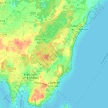
Nombre: Mapa topográfico Gstadt am Chiemsee, altitud, relieve.
Altitud media: 529 m
Altitud mínima: 515 m
Altitud máxima: 556 m
Otros mapas topográficos
Haga clic en un mapa para ver su topografía, su altitud y su relieve.
Aisching
Deutschland > Bayern > Landkreis Rosenheim > Gstadt am Chiemsee
Aisching, Gstadt am Chiemsee, Breitbrunn am Chiemsee (VGem), Landkreis Rosenheim, Bayern, 83256, Deutschland
Altitud media: 525 m