
Mapa topográfico Salisbury
Mapa interactivo
Haga clic en el mapa para ver la altitud.
Acerca de este mapa
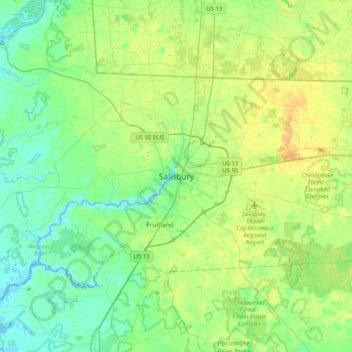
Nombre: Mapa topográfico Salisbury, altitud, relieve.
Lugar: Salisbury, Wicomico County, Maryland, 21803, United States (38.20603 -75.76100 38.52603 -75.44100)
Altitud media: 11 m
Altitud mínima: -3 m
Altitud máxima: 32 m
According to the United States Census Bureau, the city has a total area of 13.87 square miles (35.92 km2), of which 13.40 square miles (34.71 km2) is land and 0.47 square miles (1.22 km2) is water. The city has a varying elevation of 17 to 45 feet (5.2 to 13.7 m) above sea level.