
Mapa topográfico Białystok
Mapa interactivo
Haga clic en el mapa para ver la altitud.
Acerca de este mapa
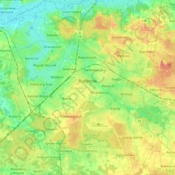
Nombre: Mapa topográfico Białystok, altitud, relieve.
Lugar: Białystok, Podlaskie Voivodeship, Poland (53.06660 23.06579 53.18860 23.24719)
Altitud media: 142 m
Altitud mínima: 110 m
Altitud máxima: 190 m
The communication system serving the entire city was made of streets radiating out from the central market square. An inventory plan made by Becker in 1799 was needed by the Prussian authorities in connection with the negotiations on the acquisition of Białystok for a royal residence. The plan is of fundamental importance as it shows the development of the city in the first period of its creation. The area of the city did not exceed 1.5 km2, and the population was approx. 3.5 thousand. The entire urban area was closed with 6 loose-fitting gates and buildings situated on regular plots. Compact buildings were found only in the market square, the frontages of which were 1- 2-storey buildings with brick front elevations. Choroska and Zamkowa Streets were built up with only brick houses. The city was dominated by the palace complex, which, together with the park, covered an area equal to the city's investment areas. The residence palace was designed on a European scale and created new development opportunities for Białystok.
Otros mapas topográficos
Haga clic en un mapa para ver su topografía, su altitud y su relieve.
Saki
Poland > Podlaskie Voivodeship > Bielsk County
Saki, gmina Bielsk Podlaski, Bielsk County, Podlaskie Voivodeship, Poland
Altitud media: 137 m
Jelenia Góra
Poland > Podlaskie Voivodeship > Sokółka County
Jelenia Góra, gmina Sokółka, Sokółka County, Podlaskie Voivodeship, Poland
Altitud media: 166 m
Osowiec
Poland > Podlaskie Voivodeship > Zambrów County
Osowiec, gmina Zambrów, Zambrów County, Podlaskie Voivodeship, Poland
Altitud media: 133 m
Augustów County
Poland > Podlaskie Voivodeship
Augustów County, Podlaskie Voivodeship, Poland
Altitud media: 135 m
Sokółka County
Poland > Podlaskie Voivodeship
Sokółka County, Podlaskie Voivodeship, Poland
Altitud media: 153 m
Siemiatycze
Poland > Podlaskie Voivodeship > Siemiatycze
Siemiatycze, powiat siemiatycki, Podlaskie Voivodeship, 17-300, Poland
Altitud media: 149 m
Białystok County
Poland > Podlaskie Voivodeship
Białystok County, Podlaskie Voivodeship, Poland
Altitud media: 152 m
Krynica
Poland > Podlaskie Voivodeship > Krynica
Krynica, gmina Michałowo, Białystok County, Podlaskie Voivodeship, Poland
Altitud media: 152 m
Harkawicze
Poland > Podlaskie Voivodeship > Harkawicze > Harkawicze
Harkawicze, gmina Szudziałowo, Sokółka County, Podlaskie Voivodeship, Poland
Altitud media: 171 m
Grodzisk
Poland > Podlaskie Voivodeship > Grodzisk
Grodzisk, gmina Grodzisk, powiat siemiatycki, Podlaskie Voivodeship, 17-315, Poland
Altitud media: 159 m
Karwowo
Poland > Podlaskie Voivodeship > Karwowo
Karwowo, gmina Rajgród, powiat grajewski, Podlaskie Voivodeship, Poland
Altitud media: 128 m
Grodzisk
Poland > Podlaskie Voivodeship > Grodzisk
Grodzisk, gmina Suchowola, powiat sokólski, Podlaskie Voivodeship, Poland
Altitud media: 163 m
Wołkusz
Poland > Podlaskie Voivodeship > Wołkusz > Wołkusz
Wołkusz, gmina Lipsk, Augustów County, Podlaskie Voivodeship, Poland
Altitud media: 116 m
Starowola
Poland > Podlaskie Voivodeship > Starowola
Starowola, gmina Jaświły, powiat moniecki, Podlaskie Voivodeship, Poland
Altitud media: 178 m
Sokółka
Poland > Podlaskie Voivodeship > Sokółka
Sokółka, gmina Sokółka, powiat sokólski, Podlaskie Voivodeship, Poland
Altitud media: 167 m