
Mapa topográfico Tur Langton
Haga clic en el mapa para ver la altitud.
Acerca de este mapa
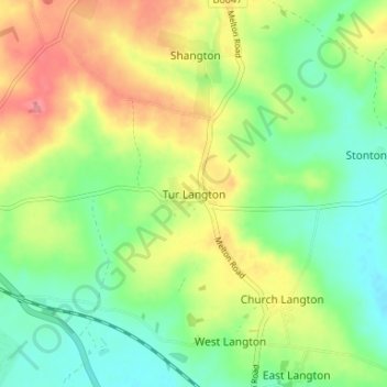
Nombre: Mapa topográfico Tur Langton, altitud, relieve.
Altitud media: 113 m
Altitud mínima: 78 m
Altitud máxima: 163 m
Otros mapas topográficos
Haga clic en un mapa para ver su topografía, su altitud y su relieve.
Burton Overy
United Kingdom > England > Leicestershire > Harborough > Burton Overy
Altitud media: 126 m
Adrian's Spinney
United Kingdom > England > Leicestershire > Harborough > Stoughton
Altitud media: 113 m
South Kilworth
United Kingdom > England > Leicestershire > Harborough > South Kilworth
Altitud media: 134 m
Broughton Astley
United Kingdom > England > Leicestershire > Harborough > Broughton Astley
Altitud media: 87 m
Kimcote and Walton
United Kingdom > England > Leicestershire > Harborough > Kimcote and Walton
Altitud media: 144 m
Little Stretton
United Kingdom > England > Leicestershire > Harborough > Little Stretton
Altitud media: 132 m
Claybrooke Magna
United Kingdom > England > Leicestershire > Harborough > Claybrooke Magna
Altitud media: 102 m
Stonton Wyville
United Kingdom > England > Leicestershire > Harborough > Stonton Wyville
Altitud media: 113 m
Saddington Reservoir
United Kingdom > England > Leicestershire > Harborough > Saddington
Altitud media: 128 m
Smeeton Westerby
United Kingdom > England > Leicestershire > Harborough > Smeeton Westerby
Altitud media: 112 m
Bruntingthorpe
United Kingdom > England > Leicestershire > Harborough > Bruntingthorpe
Altitud media: 132 m
Dunton Bassett
United Kingdom > England > Leicestershire > Harborough > Dunton Bassett
Altitud media: 115 m
Husbands Bosworth
United Kingdom > England > Leicestershire > Harborough > Husbands Bosworth
Altitud media: 142 m