
Mapa topográfico Hornton
Mapa interactivo
Haga clic en el mapa para ver la altitud.
Acerca de este mapa
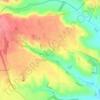
Nombre: Mapa topográfico Hornton, altitud, relieve.
Altitud media: 172 m
Altitud mínima: 127 m
Altitud máxima: 209 m
Otros mapas topográficos
Haga clic en un mapa para ver su topografía, su altitud y su relieve.
Juniper Hill
United Kingdom > England > Oxfordshire > Cherwell District > Cottisford
Juniper Hill, Cottisford, Cherwell District, Oxfordshire, England, NN13 5RN, United Kingdom
Altitud media: 126 m
Bletchingdon
United Kingdom > England > Oxfordshire > Cherwell District
Bletchingdon, Cherwell District, Oxfordshire, England, United Kingdom
Altitud media: 76 m
Bicester
United Kingdom > England > Oxfordshire > Cherwell District
Bicester, Cherwell District, Oxfordshire, England, United Kingdom
Altitud media: 76 m
Duns Tew
United Kingdom > England > Oxfordshire > Cherwell District
Duns Tew, Cherwell District, Oxfordshire, England, United Kingdom
Altitud media: 125 m
Banbury
United Kingdom > England > Oxfordshire > Cherwell District
Banbury, Cherwell District, Oxfordshire, England, United Kingdom
Altitud media: 116 m