
Mapa topográfico Hebertshausen
Mapa interactivo
Haga clic en el mapa para ver la altitud.
Acerca de este mapa
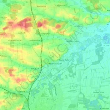
Nombre: Mapa topográfico Hebertshausen, altitud, relieve.
Lugar: Hebertshausen, Landkreis Dachau, Bayern, 85241, Deutschland (48.26239 11.41988 48.32846 11.53162)
Altitud media: 485 m
Altitud mínima: 459 m
Altitud máxima: 538 m