
Mapa topográfico Huntingdon
Mapa interactivo
Haga clic en el mapa para ver la altitud.
Acerca de este mapa
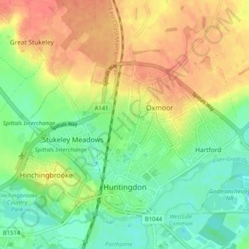
Nombre: Mapa topográfico Huntingdon, altitud, relieve.
Altitud media: 25 m
Altitud mínima: 3 m
Altitud máxima: 49 m
Otros mapas topográficos
Haga clic en un mapa para ver su topografía, su altitud y su relieve.
Old Weston
United Kingdom > England > Cambridgeshire > Huntingdonshire
Old Weston, Huntingdonshire, Cambridgeshire, East of England, England, United Kingdom
Altitud media: 65 m
Godmanchester
United Kingdom > England > Cambridgeshire > Huntingdonshire > Godmanchester
Godmanchester, Huntingdonshire, Cambridgeshire, East of England, England, United Kingdom
Altitud media: 22 m