
Mapa topográfico Bee Branch
Mapa interactivo
Haga clic en el mapa para ver la altitud.
Acerca de este mapa
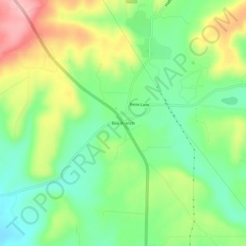
Nombre: Mapa topográfico Bee Branch, altitud, relieve.
Lugar: Bee Branch, Van Buren County, Arkansas, 72013, United States (35.43091 -92.41460 35.47091 -92.37460)
Altitud media: 251 m
Altitud mínima: 186 m
Altitud máxima: 350 m
Otros mapas topográficos
Haga clic en un mapa para ver su topografía, su altitud y su relieve.
Fairfield Bay
United States > Arkansas > Van Buren County
Fairfield Bay, Van Buren County, Arkansas, 72088, United States
Altitud media: 230 m
Shirley
United States > Arkansas > Van Buren County
Shirley, Van Buren County, Arkansas, 72153, United States
Altitud media: 205 m
Hatley Mountain
United States > Arkansas > Van Buren County
Hatley Mountain, Van Buren County, Arkansas, United States
Altitud media: 445 m
Shirley
United States > Arkansas > Van Buren County > Shirley > Shirley
Shirley, Van Buren County, Arkansas, 72153, United States
Altitud media: 213 m
Clinton
United States > Arkansas > Van Buren County
Clinton, Van Buren County, Arkansas, 72031, United States
Altitud media: 230 m
Botkinburg
United States > Arkansas > Van Buren County > Botkinburg
Botkinburg, Van Buren County, Arkansas, 72629, United States
Altitud media: 379 m