
Haz una donación
Mapa topográfico Madikeri
Haga clic en el mapa para ver la altitud.
Haz una donación
Madikeri
Madikeri features a tropical highland climate as it has an elevation of 1,170 m (3,840 ft). Madikeri is located at 12°25′N 75°44′E / 12.42°N 75.73°E / 12.42; 75.73. Madikeri lies in the Western Ghats and is a popular hill station. Nearest major cities are Hassan (110 kilometres (68 mi)) to the north, Mangaluru (138 kilometres (86 mi)) to the north-west, Mysuru (120 kilometres (75 mi)) to the east and Kannur of Kerala to the west (112 km (70 mi)). The nearest international airport is Kannur International Airport which is 90 km (56 mi) away.
Haz una donación
Acerca de este mapa
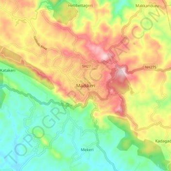
Nombre: Mapa topográfico Madikeri, altitud, relieve.
Lugar: Madikeri, Madikeri taluku, Kodagu, Karnataka, 571201, India (12.38149 75.69875 12.46149 75.77875)
Altitud media: 1,054 m
Altitud mínima: 880 m
Altitud máxima: 1,283 m
Haz una donación