
Haz una donación
Mapa topográfico Spandau
Haga clic en el mapa para ver la altitud.
Haz una donación
Acerca de este mapa
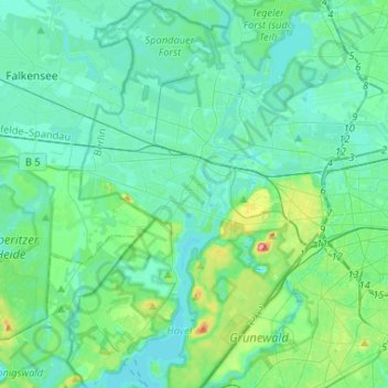
Nombre: Mapa topográfico Spandau, altitud, relieve.
Lugar: Spandau, Berlin, Germany (52.43962 13.10930 52.59880 13.28247)
Altitud media: 41 m
Altitud mínima: 26 m
Altitud máxima: 114 m
Haz una donación
Otros mapas topográficos
Haga clic en un mapa para ver su topografía, su altitud y su relieve.
Teufelsberg
Teufelsberg was originally thought to be 115 metres (377 ft) high, which placed it at the same elevation as Großer Müggelberg (the summit of Müggelberge), and was the highest point in West Berlin. New measurements show that Teufelsberg is actually 120.1 metres (394 ft) high, making it higher than Großer…
Altitud media: 54 m
Viktoriapark
On the occasion of the elevation of the monument ideas appeared to lay out a park around it. Two years later the design of a park was put out to tender. Hermann Mächtig (*1837-1909*), since 1877 Berlin's city garden director, handed in a design, already using the name Victoria Park, in honour of Princess…
Altitud media: 45 m
Haz una donación