
Gracias por apoyar a este sitio ❤️
Haz una donación
Haz una donación
Mapa topográfico Unterschneidheim
Haga clic en el mapa para ver la altitud.
Gracias por apoyar a este sitio ❤️
Haz una donación
Haz una donación
Acerca de este mapa
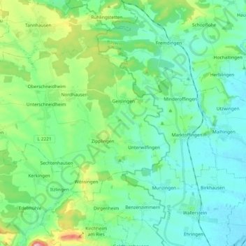
Nombre: Mapa topográfico Unterschneidheim, altitud, relieve.
Altitud media: 476 m
Altitud mínima: 420 m
Altitud máxima: 674 m
Gracias por apoyar a este sitio ❤️
Haz una donación
Haz una donación
Otros mapas topográficos
Haga clic en un mapa para ver su topografía, su altitud y su relieve.
Wilflingen
Germany > Baden-Württemberg > Ostalbkreis > Abtsgmünd
The main town of Abtsgmünd lies at the confluence of the Lein river into the Kocher (confluence elevation 367.4 m above sea level), predominantly on the left bank of the Kocher and left bank of the Lein. The furthest district of Untergröningen lies over 8 km west-northwest as the crow flies along two river…
Altitud media: 432 m
Kapfenburg
Germany > Baden-Württemberg > Ostalbkreis > Lauchheim > Domäne Kapfenburg
Altitud media: 559 m
Gracias por apoyar a este sitio ❤️
Haz una donación
Haz una donación