
Mapa topográfico Coupar Angus
Mapa interactivo
Haga clic en el mapa para ver la altitud.
Acerca de este mapa
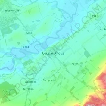
Nombre: Mapa topográfico Coupar Angus, altitud, relieve.
Altitud media: 70 m
Altitud mínima: 30 m
Altitud máxima: 298 m
Otros mapas topográficos
Haga clic en un mapa para ver su topografía, su altitud y su relieve.
Blacklunans
United Kingdom > Scotland > Perth and Kinross
Blacklunans, Perth and Kinross, Scotland, PH10 7LL, United Kingdom
Altitud media: 357 m
Perth
United Kingdom > Scotland > Perth and Kinross
Perth, Perth and Kinross, Scotland, PH1 5SU, United Kingdom
Altitud media: 131 m
Crieff
United Kingdom > Scotland > Perth and Kinross
Crieff, Perth and Kinross, Scotland, PH7 3BS, United Kingdom
Altitud media: 115 m
Forgandenny
United Kingdom > Scotland > Perth and Kinross
Forgandenny, Perth and Kinross, Scotland, PH2 9EQ, United Kingdom
Altitud media: 53 m
Blairgowrie and Rattray
United Kingdom > Scotland > Perth and Kinross > Blairgowrie and Rattray
Blairgowrie and Rattray, Perth and Kinross, Scotland, PH10 6AB, United Kingdom
Altitud media: 121 m
Kindallachan
United Kingdom > Scotland > Perth and Kinross
Kindallachan, Perth and Kinross, Scotland, PH9 0NW, United Kingdom
Altitud media: 162 m