
Mapa topográfico Villiers
Mapa interactivo
Haga clic en el mapa para ver la altitud.
Acerca de este mapa
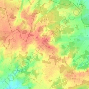
Nombre: Mapa topográfico Villiers, altitud, relieve.
Altitud media: 131 m
Altitud mínima: 100 m
Altitud máxima: 153 m
Otros mapas topográficos
Haga clic en un mapa para ver su topografía, su altitud y su relieve.
Roy
France > Centre-Val de Loire > Indre > Sainte-Gemme
Roy, Sainte-Gemme, Le Blanc, Indre, Centre-Val de Loire, Metropolitan France, 36500, France
Altitud media: 104 m
Lacs
France > Centre-Val de Loire > Indre
Lacs, La Châtre, Indre, Centre-Val de Loire, Metropolitan France, 36400, France
Altitud media: 224 m
Dun-le-Poëlier
France > Centre-Val de Loire > Indre
Dun-le-Poëlier, Issoudun, Indre, Centre-Val de Loire, Metropolitan France, 36210, France
Altitud media: 112 m
Chavin
France > Centre-Val de Loire > Indre > Chavin
Chavin, Châteauroux, Indre, Centre-Val de Loire, Metropolitan France, 36200, France
Altitud media: 230 m
Châteauroux
France > Centre-Val de Loire > Indre > Châteauroux
Châteauroux, Indre, Centre-Val de Loire, Metropolitan France, 36000, France
Altitud media: 153 m
La Châtre
France > Centre-Val de Loire > Indre
La Châtre, Indre, Centre-Val de Loire, Metropolitan France, 36400, France
Altitud media: 236 m