
Haz una donación
Mapa topográfico Cleebronn
Haga clic en el mapa para ver la altitud.
Haz una donación
Cleebronn
Cleebronn is in the Zabergäu in the south of the district of Heilbronn, directly in the north of the Stromberg mountain with an elevation of 220 to 260 metres (720 to 850 ft). The landscape is characterised by wine-growing. The symbol of the municipality and the whole Zabergäu is the Michaelsberg, which has an elevation of 394 metres (1,293 ft).
Haz una donación
Acerca de este mapa
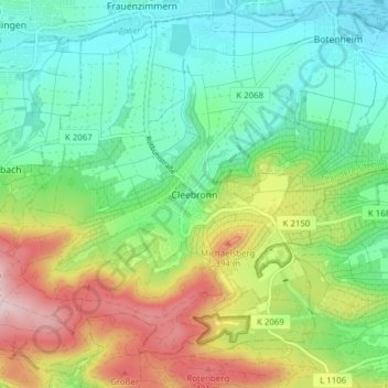
Nombre: Mapa topográfico Cleebronn, altitud, relieve.
Altitud media: 276 m
Altitud mínima: 180 m
Altitud máxima: 461 m
Haz una donación
Otros mapas topográficos
Haga clic en un mapa para ver su topografía, su altitud y su relieve.
Farnersberg
Germany > Baden-Württemberg > Landkreis Heilbronn > Beilstein > Farnersberg
Altitud media: 368 m
Haz una donación
Lampoldshausen
Germany > Baden-Württemberg > Landkreis Heilbronn > Hardthausen am Kocher > Lampoldshausen
Altitud media: 263 m