
Mapa topográfico San Juan Bautista
Mapa interactivo
Haga clic en el mapa para ver la altitud.
Acerca de este mapa
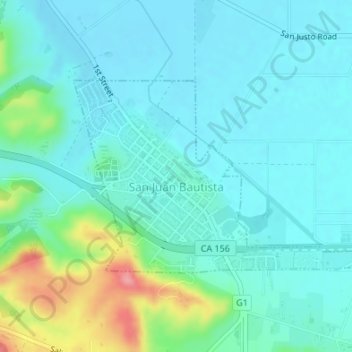
Nombre: Mapa topográfico San Juan Bautista, altitud, relieve.
Altitud media: 72 m
Altitud mínima: 50 m
Altitud máxima: 158 m
In June 1904, early aviation pioneer John J. Montgomery made a series of successful test flights using his tandem-wing glider in San Juan. This was a prototype to his 1905 gliders that were used to make the first successful high-altitude flights in heavier-than-air flying machines in the world.
Otros mapas topográficos
Haga clic en un mapa para ver su topografía, su altitud y su relieve.
Pinnacles National Park
United States > California > San Benito County
Pinnacles National Park, San Benito County, California, United States
Altitud media: 495 m
Llanada
United States > California > San Benito County
Llanada, San Benito County, California, United States
Altitud media: 490 m
Paicines
United States > California > San Benito County
Paicines, San Benito County, California, United States
Altitud media: 237 m
Hollister
United States > California > San Benito County
Hollister, San Benito County, California, 95023, United States
Altitud media: 92 m
Laguna Mountain
United States > California > San Benito County
Laguna Mountain, San Benito County, California, United States
Altitud media: 1,131 m
Fremont Peak State Park
United States > California > San Benito County
Fremont Peak State Park, San Benito County, California, United States
Altitud media: 705 m
High Peaks
United States > California > San Benito County
High Peaks, San Benito County, California, United States
Altitud media: 565 m