
Haz una donación
Mapa topográfico Koshi River
Haga clic en el mapa para ver la altitud.
Haz una donación
Koshi River
The Kosi River catchment covers six geological and climatic belts varying in altitude from above 8,000 m (26,000 ft) to 95 m (312 ft) comprising the Tibetan plateau, the Himalayas, the Himalayan mid-hill belt, the Mahabharat Range, the Siwalik Hills and the Terai. The Dudh-Koshi sub-basin alone consists of 36 glaciers and 296 glacier lakes. The Kosi River basin borders the Tsangpo River basin in the north, the Mahananda River basin in the east, the Ganges Basin in the south and the Gandaki River basin in the west. The eight tributaries of the basin upstream the Chatra Gorge include from east to west.
Haz una donación
Acerca de este mapa
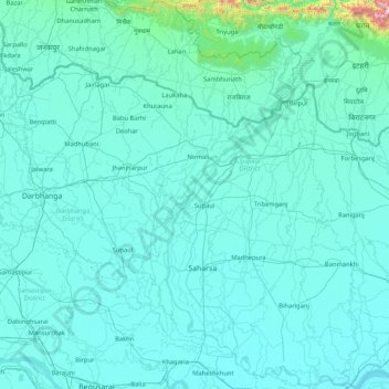
Nombre: Mapa topográfico Koshi River, altitud, relieve.
Lugar: Koshi River, Bihar, India (25.40379 86.43871 26.91017 87.26669)
Altitud media: 82 m
Altitud mínima: 24 m
Altitud máxima: 1,960 m
Haz una donación