
Mapa topográfico Noordburenweg
Mapa interactivo
Haga clic en el mapa para ver la altitud.
Acerca de este mapa
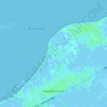
Nombre: Mapa topográfico Noordburenweg, altitud, relieve.
Altitud media: 0 m
Altitud mínima: -4 m
Altitud máxima: 9 m
Otros mapas topográficos
Haga clic en un mapa para ver su topografía, su altitud y su relieve.
Elft
Nederland > Noord-Holland > Hippolytushoef
Elft, Hippolytushoef, Hollands Kroon, Noord-Holland, Nederland, 1777 JE, Nederland
Altitud media: 0 m
Belt
Nederland > Noord-Holland > Hippolytushoef
Belt, Hippolytushoef, Hollands Kroon, Noord-Holland, Nederland, 1777 HE, Nederland
Altitud media: 0 m
Westerklief
Nederland > Noord-Holland > Hippolytushoef > Westerklief
Westerklief, Hippolytushoef, Hollands Kroon, Noord-Holland, Nederland, 1777, Nederland
Altitud media: 0 m