
Mapa topográfico Oldendorf
Mapa interactivo
Haga clic en el mapa para ver la altitud.
Acerca de este mapa
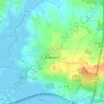
Nombre: Mapa topográfico Oldendorf, altitud, relieve.
Altitud media: 10 m
Altitud mínima: -4 m
Altitud máxima: 42 m
Otros mapas topográficos
Haga clic en un mapa para ver su topografía, su altitud y su relieve.
Horst
Duitsland > Sleeswijk-Holstein > Kreis Steinburg
Horst, Horst-Herzhorn, Kreis Steinburg, Sleeswijk-Holstein, 25358, Duitsland
Altitud media: 5 m