
Haz una donación
Mapa topográfico Glastonbury Tor
Haga clic en el mapa para ver la altitud.
Haz una donación
Acerca de este mapa
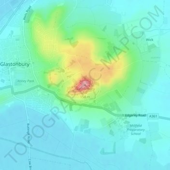
Nombre: Mapa topográfico Glastonbury Tor, altitud, relieve.
Altitud media: 33 m
Altitud mínima: 4 m
Altitud máxima: 148 m
Haz una donación
Otros mapas topográficos
Haga clic en un mapa para ver su topografía, su altitud y su relieve.
Glastonbury Tor
United Kingdom > England > Somerset > Glastonbury
The Tor is in the middle of the Summerland Meadows, part of the Somerset Levels, rising to an elevation of 518 feet (158 m). The plain is reclaimed fen above which the Tor is clearly visible for miles around. It has been described as an island, but actually sits at the western end of a peninsula washed on…
Altitud media: 33 m
Glastonbury Tor
United Kingdom > England > Somerset > Glastonbury
The Tor is almost surrounded by the low-lying Somerset Levels, rising to an elevation of 518 feet (158 m). The Levels are reclaimed fen above which the Tor is clearly visible for miles around. It has been described as an island, but actually sits at the western end of a peninsula washed on three sides by the…
Altitud media: 33 m