
Mapa topográfico Horley
Mapa interactivo
Haga clic en el mapa para ver la altitud.
Horley
Horley is at an altitude of around 54 metres above mean sea level.
Acerca de este mapa
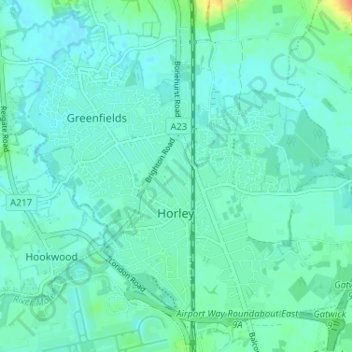
Nombre: Mapa topográfico Horley, altitud, relieve.
Lugar: Horley, Reigate and Banstead, Surrey, England, United Kingdom (51.15959 -0.19230 51.19230 -0.12775)
Altitud media: 58 m
Altitud mínima: 50 m
Altitud máxima: 92 m
Otros mapas topográficos
Haga clic en un mapa para ver su topografía, su altitud y su relieve.
Redhill
United Kingdom > England > Surrey > Reigate and Banstead
To the north, the town joins with the village of Merstham, north of which there is a "wind gap" in the chalk hills of the North Downs, at an elevation of 120 metres (390 feet) above sea level, through which the A23 road heads in from London. Geologists have speculated that there may once have been a…
Altitud media: 107 m