
Mapa topográfico Presque Isle State Park
Mapa interactivo
Haga clic en el mapa para ver la altitud.
Acerca de este mapa
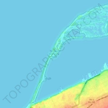
Nombre: Mapa topográfico Presque Isle State Park, altitud, relieve.
Altitud media: 177 m
Altitud mínima: 172 m
Altitud máxima: 222 m
Otros mapas topográficos
Haga clic en un mapa para ver su topografía, su altitud y su relieve.
Eagle Peak
USA > Pennsylvania > Millcreek Township
Eagle Peak, Millcreek Township, Lebanon County, Pennsylvania, 19567, USA
Altitud media: 271 m
Millcreek Township
USA > Pennsylvania > Millcreek Township
Millcreek Township, Erie County, Pennsylvania, USA
Altitud media: 302 m