
Mapa topográfico Abbeville
Mapa interactivo
Haga clic en el mapa para ver la altitud.
Acerca de este mapa
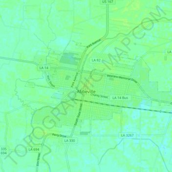
Nombre: Mapa topográfico Abbeville, altitud, relieve.
Lugar: Abbeville, Vermilion Parish, Louisiana, 70510, United States (29.95691 -92.16533 29.99695 -92.07840)
Altitud media: 5 m
Altitud mínima: -1 m
Altitud máxima: 9 m
Abbeville is located at 29°58′31.422″N 92°7′37.7652″W / 29.97539500°N 92.127157000°W / 29.97539500; -92.127157000 and has an elevation of 16 feet (4.9 m). According to the United States Census Bureau, the town has a total area of 5.7 square miles (14.7629 km2), of which 5.7 square miles (15 km2) is land and 0.04 square miles (0.10 km2) (0.53%) is water. Abbeville is located near the southern terminus of U.S. Highway 167. Abbeville Chris Crusta Memorial Airport is in the eastern part of the city. The Vermilion River runs through downtown, and several canals and coulees run through other parts of Abbeville.
Otros mapas topográficos
Haga clic en un mapa para ver su topografía, su altitud y su relieve.
Kaplan
United States > Louisiana > Vermilion Parish
Kaplan, Vermilion Parish, Louisiana, United States
Altitud media: 5 m
Indian Bayou
United States > Louisiana > Vermilion Parish
Indian Bayou, Vermilion Parish, Louisiana, United States
Altitud media: 7 m
Rose Hill
United States > Louisiana > Vermilion Parish > Rose Hill
Rose Hill, Vermilion Parish, Louisiana, 70575, United States
Altitud media: 3 m