
Haz una donación
Mapa topográfico East Quincy
Haga clic en el mapa para ver la altitud.
Haz una donación
East Quincy
East-Quincy has a Mediterranean climate (Köppen Csb) though its inland location and altitude makes it more continental and wetter than usual for this type, with very heavy snowfalls sometimes occurring in winter – the record being 133 inches (337.8 cm) in the very wet January 1916.[5][6] Although summer days are hot and only 1.4 days per winter fail to top 32 °F (0 °C), nights can be very cold and frosts occur on 179 days per year and have been recorded even in July.
Haz una donación
Acerca de este mapa
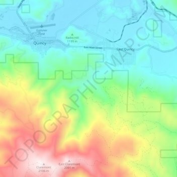
Nombre: Mapa topográfico East Quincy, altitud, relieve.
Lugar: East Quincy, Plumas County, California, United States (39.87772 -120.95454 39.95551 -120.86824)
Altitud media: 1,389 m
Altitud mínima: 1,035 m
Altitud máxima: 2,132 m
Haz una donación
Otros mapas topográficos
Haga clic en un mapa para ver su topografía, su altitud y su relieve.