
Gracias por apoyar a este sitio ❤️
Haz una donación
Haz una donación
Mapa topográfico Töging
Haga clic en el mapa para ver la altitud.
Gracias por apoyar a este sitio ❤️
Haz una donación
Haz una donación
Acerca de este mapa
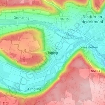
Nombre: Mapa topográfico Töging, altitud, relieve.
Altitud media: 431 m
Altitud mínima: 351 m
Altitud máxima: 536 m
Gracias por apoyar a este sitio ❤️
Haz una donación
Haz una donación
Otros mapas topográficos
Haga clic en un mapa para ver su topografía, su altitud y su relieve.
92345
Deutschland > Bayern > Landkreis Neumarkt in der Oberpfalz > Dietfurt an der Altmühl > Mühlbach
Altitud media: 476 m