
Mapa topográfico Singa
Mapa interactivo
Haga clic en el mapa para ver la altitud.
Acerca de este mapa
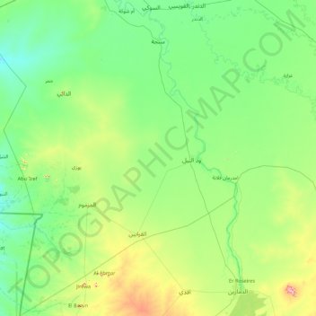
Nombre: Mapa topográfico Singa, altitud, relieve.
Lugar: Singa, Sennar State, Sudan (11.67454 33.08204 13.36110 34.34233)
Altitud media: 462 m
Altitud mínima: 400 m
Altitud máxima: 785 m
Singa (Arabic: سنجة) is a town located in the Sennar State of Sudan at an elevation of 439 meters (1,440 feet) above sea level. The town is situated on the west bank of the Blue Nile at a distance of 360 kilometers (220 miles) to the southeast of the capital, Khartoum, and 60 kilometers from Sennar city. Its population was recorded to be 259,000 in 2002.
Otros mapas topográficos
Haga clic en un mapa para ver su topografía, su altitud y su relieve.