
Haz una donación
Mapa topográfico Gosbach
Haga clic en el mapa para ver la altitud.
Haz una donación
Acerca de este mapa
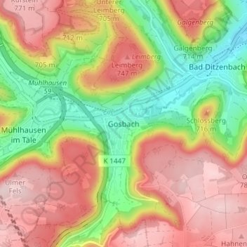
Nombre: Mapa topográfico Gosbach, altitud, relieve.
Altitud media: 650 m
Altitud mínima: 497 m
Altitud máxima: 789 m
Haz una donación
Otros mapas topográficos
Haga clic en un mapa para ver su topografía, su altitud y su relieve.
73312
Germany > Baden-Württemberg > Landkreis Göppingen > Geislingen an der Steige > Weiler ob Helfenstein
Altitud media: 615 m
Ottenbach
Germany > Baden-Württemberg > Landkreis Göppingen
Cycling: Nationally known is Ottenbach for the organization and conduct of mass sports bike marathon "Alb-extreme". The itinerary leads annually on the last Sunday in June over a distance of 190, 210 and 260 km through the countryside of the Swabian Jura with many elevations.
Altitud media: 449 m
Haz una donación
Geislingen an der Steige
Germany > Baden-Württemberg > Landkreis Göppingen
The importance of the Rorgensteig church for the religious life of the Geislingen community decreased since the elevation of the Geislingen Lady Chapel to a parish church (around 1393) and the construction of the present town church in the years 1424 to 1428. Rorgensteig with its mills had special significance…
Altitud media: 612 m
Hohenstadt
Germany > Baden-Württemberg > Landkreis Göppingen
The municipality (Gemeinde) of Hohenstadt is situated in the district of Göppingen, of the German state of Baden-Württemberg. Hohenstadt lies at the southernmost tip of Göppingen's district, along its border with the Alb-Danube district. The municipal area is physically located in the Middle Kuppenalb [de].…
Altitud media: 775 m
Eislingen/Fils
Germany > Baden-Württemberg > Landkreis Göppingen
The city (Stadt) of Eislingen is located in the north of the district of Göppingen, in the German state of Baden-Württemberg. Eislingen is physically located in the Fils river valley, at the mouth of the Krumm, in the central [de] and eastern foothills [de] of the Swabian Jura. Elevation above sea level in…
Altitud media: 369 m
Haz una donación
Deggingen
Germany > Baden-Württemberg > Landkreis Göppingen > Deggingen
The municipality (Gemeinde) of Deggingen is found in the district of Göppingen, in Baden-Württemberg, one of the 16 States of the Federal Republic of Germany. Deggingen is physically located in the upper Fils river valley, in the Filsalb region of the Middle Kuppenalb . Elevation above sea level in the…
Altitud media: 643 m
Donzdorf
Germany > Baden-Württemberg > Landkreis Göppingen
Donzdorf is located in the valley of the river Lauter, a tributary of the Fils river, 12 km east of Göppingen, on an elevation between 334 and 749 metres.
Altitud media: 526 m
Geislingen an der Steige
Germany > Baden-Württemberg > Landkreis Göppingen
The importance of the Rorgensteig church for the religious life of the Geislingen community decreased since the elevation of the Geislingen Lady Chapel to a parish church (around 1393) and the construction of the present town church in the years 1424 to 1428. Rorgensteig with its mills had special significance…
Altitud media: 612 m
Haz una donación