
Gracias por apoyar a este sitio ❤️
Haz una donación
Haz una donación
Mapa topográfico Gauting
Haga clic en el mapa para ver la altitud.
Gracias por apoyar a este sitio ❤️
Haz una donación
Haz una donación
Acerca de este mapa
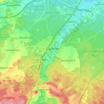
Nombre: Mapa topográfico Gauting, altitud, relieve.
Lugar: Gauting, Landkreis Starnberg, Bavaria, 82131, Germany (48.02768 11.27599 48.10133 11.42019)
Altitud media: 593 m
Altitud mínima: 541 m
Altitud máxima: 687 m
Gracias por apoyar a este sitio ❤️
Haz una donación
Haz una donación
Otros mapas topográficos
Haga clic en un mapa para ver su topografía, su altitud y su relieve.
5er-Grube
Germany > Bavaria > Landkreis Starnberg > Krailling > Kraillinger Innovations Meile KIM
Altitud media: 562 m
Gracias por apoyar a este sitio ❤️
Haz una donación
Haz una donación